|
Third Party Missions overview
|
|
|
 |
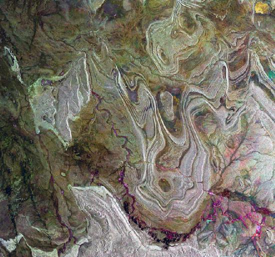
ALOS captured this image over Cardiff, Wales, on 15 June 2006 with its Advanced Visible and Near Infrared Radiometer type-2 (AVNIR-2) instrument, which is designed to chart land cover and vegetation in visible and near infrared spectral bands, with a resolution of 10 metres.
Credits: JAXA |
|
 |
 |
| |
|
|
|
CNES's Spot-4 satellite acquired this image over Australia on January 2002.
Credits: Cnes 2002 - Distribution Spot Image |
|
|
|
| |
|
|
|
Palm Island Jumeirah, Dubai.
Credits: ESA |
|
|
|
| |
|
|
|
The satellite retrieval of water constituents in coastal waters is more complex than in open ocean waters. This image shows the English Channel where a phytoplankton bloom is taking place. The mouth of the Thames is filled with suspended sediments. This picture is a SeaWiFS image taken on the 10-28-1997. Image provided by the SeaWiFS Project, NASA/Goddard Space Flight Center, and ORBIMAGE
Credits: NASA/Goddard Space Flight Center/ORBIMAGE |
|
|
|
| |
|
|
|
This image shows a part of the vast territory of the Plesetsk Cosmodrome – the only orbital launch site situated within European territory – located in the Archangel region (Arkhangelsk Oblast) of northern Russia. This image was acquired by Korea’s Kompsat-2 on 27 June 2007. ESA is supporting Kompsat-2 as a so-called 'Third Party Mission', which means ESA utilises its multi-mission European ground infrastructure to acquire, process and distribute data from the satellite to its wide scientific user community.
Credits: Kompsat-2 |
|
|
|
| |
|
|
|
This image of Mt. Fuji in Japan is the first data acquired by Japan's ALOS on 14 February 2006. ALOS is supported by ESA as a 'Third Party Mission', which means that data and imagery are distributed under a cooperative agreement between the Agency and the Japan Aerospace Exploration Agency (JAXA).
Credits: JAXA |
|
|
|
| |
|
|
|
Agricultural smallholdings outside central Tripoli are dwarfed next to a set of vast irrigated fields, as seen from the Korea Multi-purpose Satellite (KOMPSAT-1) of the Korea Aerospace Research Institute (KARI), kindly provided under ESA Third Party Mission co-operation.
Credits: KARI |
|
|
|
| |
|
|
|
The first Landsat Earth Observation satellite was launched back in 1972; images of our planet's land have been acquired continuously since then. A major benefit of this long dataset is the ability to identify gradual changes occurring on the Earth's surface. Twenty years separate these two Landsat Thematic Mapper (TM) images of Instanbul, the largest city in Turkey and the administrative capital of the Province of Istanbul. Until 1930 Istanbul was commonly known by its original Greek name Constantinople, and in Classical Antiquity as Byzantium or Byzantion. Today, with a population of between 11 and 15 million people, Istanbul is the most populated city of Turkey and is considered by some to be one of the largest cities in Europe. The old part of the city, which corresponds to ancient Constantinople, is mainly located on the south west corner of the Bosporus strait. However, the modern city is much larger and covers both the European and Asian sides of the Bosporus. The strait separates Europe from Asia and the Black Sea from the Marmara Sea. Two bridges cross the strait: the first, Bogazici (Bosporus I) bridge, was buit in 1973 and is visible only in the first image; the second, Fatih Sultan Mehmed (Bosporus II) bridge, was completed in 1988 about five kilometres north of Bosporus I. The comparison between the 1984 image on the left and the 2004 image on the right suggests that Istanbul has not undergone a substantial growth in the last 20 years. Most of changes have affected the western areas of the city. Here, the Atatürk International Airport, visible as the bright area by the coast of the Marmara Sea, on the centre left of both images, grew considerably from 1984 to 2004. Istanbul lies in one of the most seismic areas of the planet. The North Anatolian Fault, the most active fault system in Turkey, runs about 40 kilometres to the southeast of the city. one of the strongest (7.4 on the Richter scale) and most recent seismic event associated to this fault array is the Marmara earthquake. It occurred on August 17 1999 at 3:00 am (local time) and caused the death of more than 17,000 people. 44,000 were injured and damage to Turkey's industrial heartland was extensive.
Credits: © LANDSAT through ESA 2005 |
|
|
|
| |
|
|
|
|
|
|
This image taken by the MODIS instrument onboard the Terra spacecraft shows clouds passing over United Kingdom. This image was acquired by the ESA station located in Matera (Italy) on the 13th of September 2001.
Credits: ESA |
|
| |
")


